Woodlot Licence W1832 – Spring 2002
Proposed Development
- Upgrade to existing Silica Mine Road to provide access to Woodlot.
- 2 cut blocks. Both partial cuts which will retain at least 50% of current stand volume.
- Most of proposed logging is in Winlaw Creek watershed, 3.1 ha just over divide in Dumont Creek watershed.
Proposed cut blocks shown in bright yellow. Silica Mine Road upgrade shown in orange. The road runs along the black woodlot boundary, and is partly obscured by the boundary in this perspective view. Pale yellow polygons are natural meadows and deer range, red brown is ecologically sensitive terrain.
Tentative Schedule
- Late April 2002: Advertise Forest Development Plan in Valley Voice, letter to water licencees advising them of FDP and public review process. Forest Development Plan on web site at http://www.netidea.com/~tomb/ , paper copies provided to WWC.
- Early May: formal Public Viewing.
- Early June: Deadline for receipt of written comments.
- Late June: FDP submitted to Ministry of Forests for approval.
- Summer: Finalization of Site Plans (detailed prescriptions for harvesting). Review of site plans through WWC, submission of site plans to MoF.
- Fall 2002: Road maintenance and upgrade on Silica Mine Road.
- Late Fall/Winter: Logging.
W1832 is composed of two separate parcels of land near Winlaw, B.C.
- The crown land portion of the woodlot is a 598 ha area just east and uphill of Winlaw. The crown land portion is located on the height of land at the junction of the Trozzo Creek, Dumont Creek, and Winlaw Creek watersheds. Access to this area is provided by the Silica Mine Road.
Note that there are two large exclusions from W1832 in the Dumont Creek watershed area. These areas were removed from the Woodlot because they contain significant areas of ecologically sensitive terrain with dry, shallow soils and steep slopes.
- The private land portion of the woodlot is a 21 ha parcel on lower Perry’s Ridge, in the middle portion of the Dunn Creek watershed.
The management objective for Woodlot Licence W1832 is to manage the timber resources of the woodlot on a sustained yield basis following the principles of ecosystem-based management, while simultaneously maintaining or enhancing the non-timber uses, functions and products of the forest ecosystems of the woodlot. Our long term goals are the development of diverse forest stands of mixed species and mixed ages, the maintenance of biodiversity, and the management of ecologically important forest structures.
Watershed management issues are the key non-timber component of forest and land use in W1832. The crown portion of W1832 occupies much of the remaining forested area in the Dumont Creek watershed, which is the source of domestic and agricultural water for many water licensees. The crown portion also occupies parts of the Trozzo Creek and Winlaw Creek watersheds, much larger hydrologic systems which are also domestic water sources, and a small portion of the Woodward Face watershed between Winlaw and Dumont Creeks. The private land portion of W1832 is on the lower slopes of Perry’s Ridge, in the Dunn Creek watershed, a small creek which is also a domestic water source. Our watershed management objective is to have no detrimental impact on the quantity, quality and/or timing of flow of water supplies.
The crown land portion of W1832 is an area of stepped terrain, composed of a repeated series of flat benches, moist areas, short cliffs, and dry, rocky ridges. The varied terrain results in varying soil depth, site moisture, and vegetation communities across the woodlot. A total of 31% of the crown land portion of W1832 has been classed as ecologically sensitive or as ungulate winter range in the Management Plan.
Forests in the crown portion regenerated following a hot, stand replacement forest fire in 1912, and are dominated by relatively even aged stands of Douglas-fir, larch and lodgepole pine. Moist sites also have a cedar and hemlock understory. Little logging activity has taken place on the crown portion of W1832 to date. Human disturbance following the fire seems limited to mining exploration activity and possibly some cedar salvage.
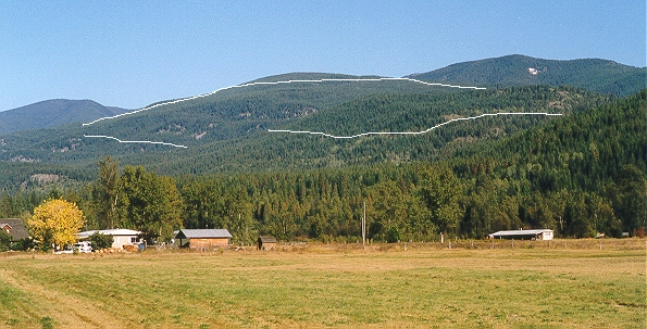
W1832 from Slocan River Road, south of Winlaw. The approximate boundary of the woodlot is sketched in white.